We're fortunate to have several dedicated volunteers who help with our conservation restriction stewardship work. One volunteer, Dean-Lorenz Szumylo (pictured here with CR Monitoring Specialist Sally Naser), inspects several properties on the North Shore, while others help keep an eye on CRs on the south shore, in the metrowest region, and the Berkshires. Also, this summer we hosted a Vermont Law School intern who helped with numerous legal issues on CRs located throughout the state.
From all of us at the CR Program to our volunteers -- "Thanks!"
Friday, August 12, 2011
Helping hands from volunteers
Wednesday, August 10, 2011
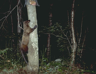
Fisher cats rebounding in Massachusetts
On a recent trip to Fitchburg to inspect our newest conservation restriction we were fortunate to see a Fisher. Sometimes called a fisher cat, the Martes pennanti is actually a member of the weasel family that includes the mink, otter, and skunk. An adult can grow up to 16 pounds and measure 3 feet from head to tail. These agile and elusive animals were nearly driven to extinction in Massachusetts from loss of forest habitat and trapping, but have made a remarkable comeback in recent decades. It was exciting to see such a beautiful, wild creature sprint across the forest floor and then run straight up a tree....quite a sight in the middle of a city!
 |
| Source USFWS |
Thursday, August 4, 2011
Simple and Timeless Field Monitoring Tools
Complicated CR documents often contain very specific language regarding areas where a landowner may and may not exercise certain reserved rights. For example, a building envelope typically allows an owner to maintain existing structures and build new ones as negotiated in the CR document. Areas such as these have, ideally, been physically monumented by a professional surveyor and labeled, with metes and bounds (distances and bearings) on the property's survey or plan of land. For example, a CR might state that, on a certain part of the property, no reserved-right construction activity may occur within a certain distance of a sensitive resource area, such as a wetland.
Sometimes Trustees' monitoring staff need to check these distances in the field, or determine exactly where a property or building envelope boundary lies. Below we highlight two simple but indispensable tools for such determinations.
In the first picture below, staff employ a good old-fashioned tool - a simple tape measure - to determine the distance from a restricted property boundary to new construction on the same landowner's unrestricted parcel. Here, the measurement point was a professional surveyor's monument on the boundary line of the restricted property, allowing us to be sure that we were measuring from a very exact reference point out to the construction area.
Trustees' Staff Measuring from a survey monument to new construction: Kelley Whitmore (Community Conservation Specialist), Left. Andrew Bentley (CR Stewardship Assistant), Right. Anthony Orlando (CR Enforcement Ranger), far end of tape.
Other times, it is necessary to determine exactly where a property line lies. In New England, we often, but certainly not always, have the benefit of historic stone wall boundaries to help us. Modern technology supplies us with GPS units, which are nice approximators, but ours have a margin of error ranging from 5 to 15 feet, depending on satellite reception. However, with the help of a survey and the timeless and indispensable tool pictured below, we are able to determine that boundary within a much more precise margin of error - a margin which only a professional surveyor could best. You may have already guessed what tool that is, and here it is -

Other times, it is necessary to determine exactly where a property line lies. In New England, we often, but certainly not always, have the benefit of historic stone wall boundaries to help us. Modern technology supplies us with GPS units, which are nice approximators, but ours have a margin of error ranging from 5 to 15 feet, depending on satellite reception. However, with the help of a survey and the timeless and indispensable tool pictured below, we are able to determine that boundary within a much more precise margin of error - a margin which only a professional surveyor could best. You may have already guessed what tool that is, and here it is -

Sally Naser, standing on a survey corner monument, sights Andrew Bentley down the property line with a compass.
Subscribe to:
Posts (Atom)


